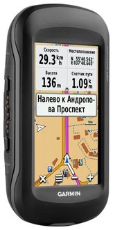
Garmin Montana 680
detailed information
9.8 / 10
Rating
Characteristics of the Garmin Montana 680
| Main | |
|---|---|
| Type of | portable |
| Application area | universal |
| GLONASS support | there is |
| Software | Garmin |
| Number of waypoints | 4000 |
| Number of routes | 200 |
| Track Log Capacity | 10,000 points |
| Built-in card | there is |
| Ability to download maps | there is |
| The possibility of using raster maps | there is |
| Route calculation function | there is |
| Voice messages | there is |
| Sound alarm | there is |
| Traveling computer | there is |
| Track-Back function | there is |
| Screen | |
| Screen type | LCD color |
| Screen diagonal | 4 inch. |
| Screen size | 5.06x8.93 cm |
| Screen resolution | 272x480 pix. |
| Touch screen | there is |
| Device characteristics | |
| Built-in memory size | 8 GB |
| EGNOS support | there is |
| WAAS support | there is |
| Antenna type | internal |
| Connector for external antenna | there is |
| Functions | |
| Multimedia | view photo |
| Additionally | barometer, magnetic compass |
| Nutrition | |
| Batteries | own li-ion |
| The number of batteries | 1 |
| Working hours | 16 h |
| Connection of external power supply (12 V) | there is |
| The ability to charge batteries | there is |
| Interfaces | |
| Connection | USB |
| NMEA 0183 support | there is |
| Slot | Micro sd |
| Headphone jack | there is |
| Additionally | |
| Waterproof case | there is |
| Equipment | Pre-installed maps Roads of Russia. RF. TOPO., Subscription to the BirdsEye satellite image for 1 year; lithium-ion battery pack, USB cable, AC charger, user manual, brief instructions |
| Dimensions (WxHxD) | 144x75x36 mm |
| Weight | 333 g |
| Features | built-in 8 megapixel camera, ANT +, dual orientation, the ability to work with gloves; battery type: rechargeable lithium-ion (included) (up to 16 hours) or 3 AA batteries (not included) (up to 22 hours), NiMH or lithium batteries are recommended; hunting / fishing calendar, Sun / Moon information, tide tables, area calculation, alarm clock, timer, stopwatch, calendar, calculator |
Garmin Montana 680 Reviews
Evaluation
5
Advantages: The most perfect tourist navigator from the Garmin series.
Disadvantages: Hardly ever!
Comment: Perfect fit case for this model Lowepro Tahoe 25 II
Irina Vikova
July 04, 2018
Evaluation
5
Advantages: Screen, level of protection. Cards.
Comment: I use already navigators Garmin. Checked in various campaigns and on the water and on bicycles How did you travel around Europe with him, well, almost all of Russia traveled. Of course, it’s not very convenient that the map consists of two parts, especially when the route Nizhny Novgorod - Karelia - Baikal, but you can get used to everything. Indestructibility and reliability all forgive.
Dmitry Koltsov
April 27, 2018
Evaluation
5
Comment: A cool model with a large high-quality screen, it’s a pleasure to see such a clear color picture, the old navigator from another company doesn’t fit like a candle)) The sensor also doesn’t hang when pressed, responds quickly. It keeps the battery in good condition, which for me personally was one of the most important criteria, I didn’t want to bother with constant recharging on trips, the charge lasts almost a whole day! The case is comfortable, and the dimensions are what you need to carry in your pocket, or hang around your neck on a cord - it is light and comfortable. Well, the waterproof class of the case is more than pleased, ipx7 has such a high degree of impermeability, enough head to take it with you for rafting, or for kayak raids)) From the functionality I’ll note a super-clear compass and altmeter, and other standard buns work normally) I am satisfied with the device, it is really easy and convenient to use it!
Roman Sh.
February 26, 2016
Evaluation
5
Comment: An excellent function navigator, chose it for a beloved man from behind the screen, all the information is displayed on it and it is very convenient to use it, with other navigators the picture seemed to me not so clear. You can use the car, it loads the maps quickly and we have repeatedly used it to search for the most convenient way, well, in hiking it is very useful, it records the route of movement, there is a compass, even the height is measured! It is always interesting to see how many kilometers are covered, a decent mileage was wound around Karelia, and you would even know about it without a navigator)) , in such a hand it lies comfortably and does not slip, even when it is wet)) Navigation is the simplest, she figured out everything in a few minutes, although I have a full kettle with similar gadgets))) In a word, it’s a quality and irreplaceable device for city )
Natalie
February 19, 2016
Evaluation
5
Comment: I took this for myself a year ago, I enter a tourist group and every year we go through uncharted back streets of our country, I will say frankly, never let me down. I chose a navigator, mainly for reviews. The main thing I needed was such that it was convenient, it was possible to update the map, the electronic compass and small things, there is a built-in camera, a router, etc. In this navigator collected all the best and necessary. By design, I would like to note that the main thing is ease, ease of use, waterproof and sturdy case (we walk through the mountains and along the mountains) and charge for a long time, until about 16 hours, then you can change the battery before recharging. The display is color touch, you can work in gloves, which is really convenient. This navigator easily connects to GLONASS and GPS satellites, while providing very fast, accurate and reliable navigation. 8 memory here, you can save and photograph and record the passed coordinates and routes. There is an altimeter, especially in the mountains. Gives a summary list for the full route, if anything, you can manually adjust the route. Great stuff!
Vega
February 13, 2016
Garmin Montana 680 is selected to the rating:
8 best tourist navigators